

Aral Sea
From Wikipedia, the free encyclopedia
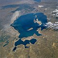
The Aral Sea (Kazakh: Арал Теңізі Aral Teñizi; Uzbek: Orol Dengizi; Russian: Аральскοе Мοре Aral'skoye More; Tajik: Баҳри Арал Bakhri Aral; Persian: دریای خوارزم Daryâ-ye Khârazm) was a lake that lay between Kazakhstan (Aktobe and Kyzylorda provinces) in the north and Karakalpakstan, an autonomous region of Uzbekistan, in the south. The name roughly translates as "Sea of Islands", referring to more than 1,534 islands that once dotted its waters; in Old Turkic "aral" is island and thicket.[3]
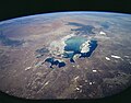
Formerly one of the four largest lakes in the world with an area of 68,000 square kilometres (26,300 sq mi), the Aral Sea has been steadily shrinking since the 1960s after the rivers that fed it were diverted by Soviet irrigation projects. By 2007, it had declined to 10% of its original size, splitting into four lakes – the North Aral Sea, the eastern and western basins of the once far larger South Aral Sea and one smaller lake between North and South Aral Seas.[4] By 2009, the southeastern lake had disappeared and the southwestern lake retreated to a thin strip at the extreme west of the former southern sea.[5] The maximum depth of the North Aral Sea is 42 m (138 ft) (as of 2008).[1]
The shrinking of the Aral Sea has been called "one of the planet's worst environmental disasters".[6] The region's once prosperous fishing industry has been essentially destroyed, bringing unemployment and economic hardship. The Aral Sea region is also heavily polluted, with consequent serious public health problems. The retreat of the sea has reportedly also caused local climate change, with summers becoming hotter and drier, and winters colder and longer.[7]
In an ongoing effort in Kazakhstan to save and replenish the North Aral Sea, a dam project was completed in 2005; in 2008, the water level in this lake had risen by 24 m (79 ft) from its lowest level in 2007.[8] Salinity has dropped, and fish are again found in sufficient numbers for some fishing to be viable.[citation needed] However, the outlook for the remnants of the South Aral Sea remains bleak.
Irrigation canals

 Satellite images show the changing water levels in the Aral Sea from 2000 through 2011.
In the early 1960s,[11] the Soviet government decided the two rivers that fed the Aral Sea, the Amu Darya in the south and the Syr Darya in the northeast, would be diverted to irrigate the desert, in an attempt to grow rice, melons, cereals, and cotton.
Satellite images show the changing water levels in the Aral Sea from 2000 through 2011.
In the early 1960s,[11] the Soviet government decided the two rivers that fed the Aral Sea, the Amu Darya in the south and the Syr Darya in the northeast, would be diverted to irrigate the desert, in an attempt to grow rice, melons, cereals, and cotton.
This was part of the Soviet plan for cotton, or "white gold", to become a major export. This eventually succeeded, and today Uzbekistan is one of the world's largest exporters of cotton.[12]
The construction of irrigation canals began on a large scale in the 1940s. Many of the canals were poorly built, allowing water to leak or evaporate. From the Qaraqum Canal, the largest in Central Asia, perhaps 30 to 75% of the water went to waste. Today, only 12% of Uzbekistan's irrigation canal length is waterproofed.
Impact on environment, economy and public health
The ecosystems of the Aral Sea and the river deltas feeding into it have been nearly destroyed, not least because of the much higher salinity. The receding sea has left huge plains covered with salt and toxic chemicals – the results of weapons testing, industrial projects, pesticides and fertilizer runoff – which are picked up and carried away by the wind as toxic dust and spread to the surrounding area. The land around the Aral Sea is heavily polluted, and the people living in the area are suffering from a lack of fresh water and health problems, including high rates of certain forms of cancer and lung diseases. Respiratory illnesses, including tuberculosis (most of which is drug resistant) and cancer, digestive disorders, anaemia, and infectious diseases are common ailments in the region. Liver, kidney and eye problems can also be attributed to the toxic dust storms. Health concerns associated with the region are a cause for an unusually high fatality rate amongst vulnerable parts of the population. There is a high child mortality rate of 75 in every 1,000 newborns and maternity death of 12 in every 1,000 women.
[18] Crops in the region are destroyed by salt being deposited onto the land. Vast salt plains exposed by the shrinking Aral have produced dust storms, making regional winters colder and summers hotter.[19][20][21][22]
The Aral Sea fishing industry, which in its heyday had employed some 40,000 and reportedly produced one-sixth of the Soviet Union's entire fish catch, has been devastated, and former fishing towns along the original shores have become ship graveyards. The town of Moynaq in Uzbekistan had a thriving harbor and fishing industry that employed approximately 30,000 people;[23] now it lies miles from the shore. Fishing boats lie scattered on the dry land that was once covered by water; many have been there for 20 years. The only significant fishing company left in the area has its fish shipped from the Baltic Sea, thousands of kilometers away.
Also destroyed is the muskrat trapping industry in the deltas of Amu Darya and Syr Darya, which used to yield as many as 500,000 muskrat pelts a year.[14]
The overall cost of the damage to the region has been estimated at 35-40 billion roubles (£800 million).[24]


http://en.wikipedia.org/wiki/Aral_Sea
Formerly one of the four largest lakes in the world with an area of 68,000 square kilometres (26,300 sq mi), the Aral Sea has been steadily shrinking since the 1960s after the rivers that fed it were diverted by Soviet irrigation projects. By 2007, it had declined to 10% of its original size, splitting into four lakes – the North Aral Sea, the eastern and western basins of the once far larger South Aral Sea and one smaller lake between North and South Aral Seas.[4] By 2009, the southeastern lake had disappeared and the southwestern lake retreated to a thin strip at the extreme west of the former southern sea.[5] The maximum depth of the North Aral Sea is 42 m (138 ft) (as of 2008).[1]
The shrinking of the Aral Sea has been called "one of the planet's worst environmental disasters".[6] The region's once prosperous fishing industry has been essentially destroyed, bringing unemployment and economic hardship. The Aral Sea region is also heavily polluted, with consequent serious public health problems. The retreat of the sea has reportedly also caused local climate change, with summers becoming hotter and drier, and winters colder and longer.[7]
In an ongoing effort in Kazakhstan to save and replenish the North Aral Sea, a dam project was completed in 2005; in 2008, the water level in this lake had risen by 24 m (79 ft) from its lowest level in 2007.[8] Salinity has dropped, and fish are again found in sufficient numbers for some fishing to be viable.[citation needed] However, the outlook for the remnants of the South Aral Sea remains bleak.
Irrigation canals
Further information: Great Plan for the Transformation of Nature
This was part of the Soviet plan for cotton, or "white gold", to become a major export. This eventually succeeded, and today Uzbekistan is one of the world's largest exporters of cotton.[12]
The construction of irrigation canals began on a large scale in the 1940s. Many of the canals were poorly built, allowing water to leak or evaporate. From the Qaraqum Canal, the largest in Central Asia, perhaps 30 to 75% of the water went to waste. Today, only 12% of Uzbekistan's irrigation canal length is waterproofed.
Impact on environment, economy and public health
The ecosystems of the Aral Sea and the river deltas feeding into it have been nearly destroyed, not least because of the much higher salinity. The receding sea has left huge plains covered with salt and toxic chemicals – the results of weapons testing, industrial projects, pesticides and fertilizer runoff – which are picked up and carried away by the wind as toxic dust and spread to the surrounding area. The land around the Aral Sea is heavily polluted, and the people living in the area are suffering from a lack of fresh water and health problems, including high rates of certain forms of cancer and lung diseases. Respiratory illnesses, including tuberculosis (most of which is drug resistant) and cancer, digestive disorders, anaemia, and infectious diseases are common ailments in the region. Liver, kidney and eye problems can also be attributed to the toxic dust storms. Health concerns associated with the region are a cause for an unusually high fatality rate amongst vulnerable parts of the population. There is a high child mortality rate of 75 in every 1,000 newborns and maternity death of 12 in every 1,000 women.
[18] Crops in the region are destroyed by salt being deposited onto the land. Vast salt plains exposed by the shrinking Aral have produced dust storms, making regional winters colder and summers hotter.[19][20][21][22]
The Aral Sea fishing industry, which in its heyday had employed some 40,000 and reportedly produced one-sixth of the Soviet Union's entire fish catch, has been devastated, and former fishing towns along the original shores have become ship graveyards. The town of Moynaq in Uzbekistan had a thriving harbor and fishing industry that employed approximately 30,000 people;[23] now it lies miles from the shore. Fishing boats lie scattered on the dry land that was once covered by water; many have been there for 20 years. The only significant fishing company left in the area has its fish shipped from the Baltic Sea, thousands of kilometers away.
Also destroyed is the muskrat trapping industry in the deltas of Amu Darya and Syr Darya, which used to yield as many as 500,000 muskrat pelts a year.[14]
The overall cost of the damage to the region has been estimated at 35-40 billion roubles (£800 million).[24]

The shrinking of the Aral Sea.

Aral Sea from space, August 1985
_NASA_STS085-503-119.jpg)
Aral Sea from space, 1997

Aral Sea from space, August 2009
No comments:
Post a Comment